In line with Google’s mission which is to organize the
world’s information and to make it universally accessible and useful, this
influential international company again releases a latest update of their Maps
and Earth this month. After they publicized their imagery updates for Google
Maps and Earth in the month of September, Google just recently announced new
updates in its 45°, aerial and satellite imagery.
 |
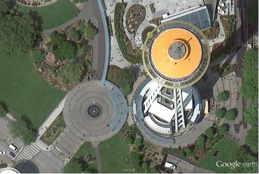
Space Needle, Seattle
|
Google has expanded its high-resolution Maps and Earth
to cover a whopping 164 cities and 108 countries. Highlights include a live
look at the Space Needle’s orange paint job for its 50th
anniversary, overhead look at Austrian bridges and an angled view of the Thun
Castle in Switzerland. On the other hand, its brand new 45-degree imagery is
now available for 60 cities – 40 in the United States and 20 other countries
abroad. Luxemburg and Romania are surprisingly included for the first time.
Google Maps and Earth always provide us the best search functionalities and robust
navigation options. Google Earth showcases the best 3D Imagery, 3D Buildings,
Historical Imagery and more awesome features you shouldn't dare miss to
explore. Google Maps remains to be a user-friendly service that offers detailed
directions and even premium imagery.
Google’s Imagery update portrays to us a breath taking
views of popular and gorgeous places worldwide. This innovative change in Maps
and Earth signifies Google’s dedication to give us utmost comprehensive and
accurate maps. This further proves how undeniably dominant Google is in this
field!


2 comments:
Nice post. With Google’s update in its map application, it seems to give them more edge against other service providers. Thanks for sharing.
Yeah I really agree with you, @Luma stylus and every update makes it more credible to use. amazing post by the way
Post a Comment